This is the third publication in the series "reverse geolocation search"! We would like to remind you about the first article of the series and the second one. With these publications, we want to prove once again that even in times of war, you can find a place to learn and strengthen your investigative skills. Moreover, these opportunities become more numerous during the war.
This time we will again analyze the case of defeating the positions of the Russian military. And first, we wish to thank the Armed Forces of Ukraine for their excellent work. Thank you! You are making death to the enemies, we bow to you and respect you.
Anonymous sources of Molfar OSINT community
An anonymous member of the Molfar OSINT community shared with us a screenshot of a message from a Viber group where he was added as a resident of Crimea who allegedly wants to help the Russian army in the war against Ukraine 😏
After all, this is true partisanship! And it is brave, but dangerous. So if you have information that you feel you need to share, share it only with complete security. If the risks are too big, hold the data until better times.
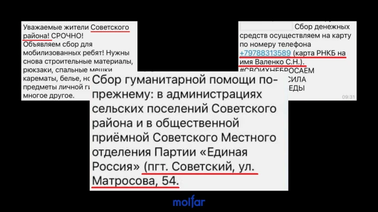
After receiving this information at the end of November 2022, we checked the location indicated in the message – Soviet settlement. It is quite likely that the collected volunteer aid is accumulated in this place for further transfer to the Russian occupiers. We marked a place for ourselves, saved copies of the posts and went about other things, until…
Strike on the base of the Russian occupiers: hundreds, possibly thousands of victims
Reports of a "fire in the barracks" began to appear in the morning of December 10 (1, 2. 3). At first, these were just reports about the fire, later the local news sources began to indicate the reason – "careless handling of fire". And judging by this video, carelessness cost Russian soldiers significant material and personnel losses.
But we all understand perfectly that this could most likely have been a strike by the Armed Forces of Ukraine against the positions of Russian soldiers. Hence, we have two questions:
- How was the base identified?
- What weapon was used to strike?
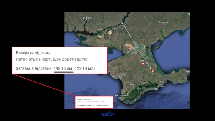
In this case, we were interested in two points: the distance and the specifics of the settlement. The approximate launch distance of the projectile should be at least 200 km, officially Ukraine does not have weapons capable of hitting targets at such distances. And the second is specificity of the settlement. We immediately asked ourselves: why would the Armed Forces strike targets that are so far from the front line? Was there something in this Soviet that really deserved more attention than other, less distant objects from the front? We were looking for an answer to these two questions.
How did the Armed Forces get the coordinates of the object for the attack?
This article began with insider information provided by a member of the Molfar OSINT community. It was also possible to assume that the General Staff received data for the defeat from the Crimean partisans, and worked on the goal. But we at Molfar know that most of the information has to be searched independently and checked many times. And it is open sources that deserve the most attention: firstly, they contain the most data, and secondly, they can be confirmed or denied easily. We also assumed that it is unlikely that the General Staff was able to give an order to attack the object, relying only on insider information. We bet on our own guesses, and we were right!
Data search methodology.
- First, we opened a folder in Telegram, which contains all the Crimean pro-Russian news sources.
- Next, we used a search with the query "Советское" (Soviet), name of the settlement written in Russian.
- The information we found did not allow us to establish an exact location.
- Then we went to the comments on the posts about the "fire in the barracks", and under the guise of a volunteer tried to find out information, argued our interest in helping the heroes of Russia overcome the consequences of the fire, sending them food, clothes, cigarettes. A cynical lie, but it worked.
- After a series of crossing between various informational sources and groups, in each of which we checked the information through a search with the query "Советское" (Soviet), in the end we managed to reach a Telegram-public called "FOR YOUR FRIENDS. Aid to the Southern Front". And there we found a publication from November 29, in which a photo and a video were presented: against the background of industrial buildings, the Crimean-Moscow priests distribute humanitarian aid to future victims of fire. Bingo!
So, this is definitely the settlement of Soviet, this is definitely the Russian military – and this is a sufficient number of media files to establish the exact geolocation. So, let's get to work.
Reverse search for the coordinates of Russian soldiers: geolocation by photo
Let's start in reverse order.
📍 The coordinates of the object that we managed to establish: 45.34638644206905, 34.93800732678438
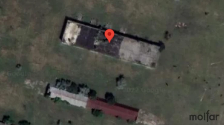
November 29 in the group "FOR YOUR FRIENDS. "Help to the Southern Front" published the transferring of humanitarian aid from volunteers to Russian military personnel. The published photos and videos show at least 20 Russian soldiers. The place is identified by the location and color of the two buildings, as well as the location of the trees between them.
Since we had "insider information from Viber", shared by a member of the Molfar OSINT community, we immediately started looking in Soviet settlement.
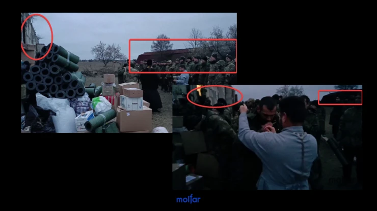
In the photo, where humanitarian aid and Russian military personnel are visible, there is a long brown-red building, and opposite it – a gray building.
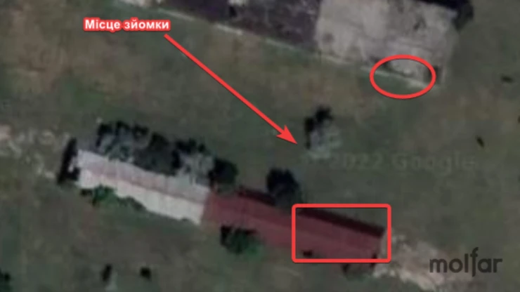
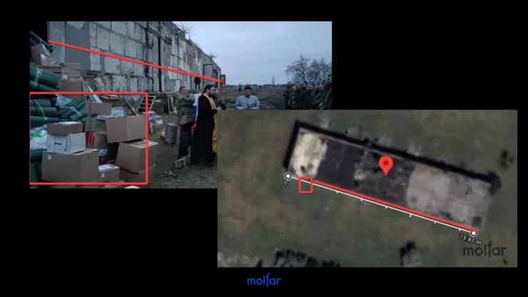
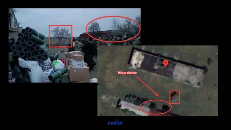
There is one single tree in the middle of the buildings, and several trees are lined up next to the building with a brown-red roof. The same location of the trees can be seen on Google Map.
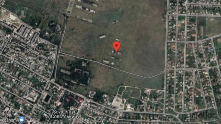
So, the place is found. And if you judge by the length of the building, and also assume that the neighboring buildings were also used as barracks or warehouses, the damage to the enemy was considerable, the losses are unlikely to be only a couple of mobilized men, most likely the number of killed is measured in dozens. It is also worth noting that sanitary losses during fires are usually very high.
Conclusions: What type of weapon was used?
According to the first version of the remote strike, most likely, it was one of the UAVs of Ukrainian or Western production, which are currently undergoing active testing on the battlefields in Ukraine. According to Oleg Boldyrev, head of projects at Ukroboronprom: Ukrainian drones are already flying, Western drones have a unique opportunity "to be quickly tested in Ukraine", besides, Ukraine has other types of weapons for launching strikes deep in the rear of the Russian Federation.
And the second version, which requires additional confirmation, is the partisans. Partisan movement "ATESH" (movement of Ukrainians and Crimean Tatars) announced that its activists were involved in setting fire to barracks with Russian military personnel in Soviet settlement in occupied Crimea. They said it in their official Telegram channel. According to their calculations, at least nine Russian soldiers died during the fire.
On this, we wish you attention, inspiration and joy from learning new things. War is a window of opportunity. Thank you for continuing of studying despite all the difficulties. We continue together!
✉️ To contact the team and receive a comment, fill out the form below, or send your request to: [email protected]